
TranceAddict Forums (www.tranceaddict.com/forums)
- Political Discussion / Debate
-- Yet another underwater ancient city discovered
Pages (4): « 1 2 [3] 4 »
| quote: |
| Originally posted by Q5echo the strangest thing i saw at AUTEC was flying fish. very cool. up until that time i thought flying fish were legends like mermaids or some shit |
| quote: |
| Originally posted by culorut You need to see things to believe that they are real? Ever for once think that there are many more things which you will never see that actually exist? Point proven. |
| quote: |
| Originally posted by culorut You need to see things to believe that they are real? Ever for once think that there are many more things which you will never see that actually exist? Point proven. |
Legend, LOL.

| quote: |
| Originally posted by culorut Legend, LOL. |

No offense to everyone here, but I dont like the direction of this thread at the moment. The purpose of this thread is not another conspiracy debate, but sharing of information on ancient civilizations, cultures and what they left for us to learn about them. I know its fun mocking the perfectly round rocks and giant seabed smooth structures for alien agenda, but thats far from the point.
I would like to make this thread a collection of links, photos, articles and such of ancient, lost and forgotten civilizations on Earth using the uncovered artifacts and/or related topics. I know I myself have probably deviated my own discussion, my apoligies, and I hope we dont end up filling up this thread with pointless and hopeless debate about UFO bases on the planet ... no matter of the beliefs.
When I posted all the information, I did it not with an intention of making it look like aliens did it all, but basically saying that there's more to our ancestors that what history is telling us. Our ancestors had access to far more sophisticated knowledge and technology that we could have ever thought of, but all of it was lost in history and time. Maybe aliens (or more likely past advanced civilizations) did play a role, the emphasis is to study more about these things and put into perspective the possible technology and knowledge at the time used, and the key point is to try to do some of your own follow-up research and conclusions.
| quote: |
| Originally posted by pkcRAISTLIN magnetonium thinks it was aliens. |

| quote: |
| Originally posted by culorut You need to see things to believe that they are real? Ever for once think that there are many more things which you will never see that actually exist? Point proven. |
| quote: |
| Originally posted by culorut Legend, LOL. |
http://en.rian.ru/analysis/20071227/94372640.html
Remains of ancient civilization discovered on the bottom of a Kyrgyz lake
quote:
An international archeological expedition to Lake Issyk Kul, high in the Kyrgyz mountains, proves the existence of an advanced civilization 25 centuries ago, equal in development to the Hellenic civilizations of the northern coast of the Pontus Euxinus (Black Sea) and the Mediterranean coast of Egypt.
The expedition resulted in sensational finds, including the discovery of major settlements, presently buried underwater. The data and artefacts obtained, which are currently under study, apply the finishing touches to the many years of exploration in the lake, made by seven previous expeditions. The addition of a previously unknown culture to the treasury of history extends the idea of the patterns and regularities of human development.
Kyrgyz historians, led by Vladimir Ploskikh, vice president of the Kyrgyz Academy of Sciences, worked side-by-side with Russian colleagues, lead by historian Svetlana Lukashova and myself. All the Russians involved were experienced skin-divers and members of the Russian Confederation of Underwater Sports. We were responsible for the work done under water. Scuba divers ventured into the lake many times to study its bottom.
Last year, we worked near the north coast at depths of 5-10 metres to discover formidable walls, some stretching for 500 meters-traces of a large city with an area of several square kilometers. In other words, it was a metropolis in its time. We also found Scythian burial mounds, eroded by waves over the centuries, and numerous well preserved artifacts-bronze battleaxes, arrowheads, self-sharpening daggers, objects discarded by smiths, casting molds, and a faceted gold bar, which was a monetary unit of the time.
Lake Issyk Kul has played a tremendous role since the inception of human history due to its geographic location at the crossing of Indo-Aryan and other nomadic routes. Archeologists found traces of many religions here-Zoroastrianism, Buddhism, Judaism, Christianity and Islam. Somewhere in the vicinity was Chihu, the metropolitan city of a mighty state of Wusung nomads, which ancient Chinese chronicles mentioned on many occasions.
The Great Silk Road lay along the lake's coast until the 18th century. Even today, the descendants of caravan drivers recollect their ancestors' stories about travelling from Asia to Europe and back.
Tamerlane built a fortress on one of the lake islets to hold aristocratic captives and keep his treasures. The famous Asian expeditions of Russian explorers Dmitry Przhevalsky and Pyotr Semyonov-Tianshansky started from that spot.
The latter left us an enticing mystery. When he visited Venice in 1850, he looked at the Catalan Atlas of 1375 and came across a picture of a lakeside monastery with the caption: "The spot is named Isikol. Here is a monastery of Armenian brethren, which is rumored to possess the relics of St. Matthew the Apostle and Evangelist."
Semyonov-Tianshansky embarked on a relentless but vain search for the shrine. To all appearances, the monastery was engulfed by water. Hydrologists have not to this day sufficiently studied the unique lake with regular shifts in its water level. Some changes are gradual, others sudden and disastrous since they are caused by earthquakes and torrents of water rush from lakes higher up in the mountains. Floods recede sooner or later, and people come back to the shores-only to become the victims of other floods 500-700 years later.
Throughout the years of their partnership, Russian and Kyrgyz archeologists discovered and examined more than ten major flooded urban and rural settlements of varying ages. Their ample finds generously add to present-day ideas of everyday life in times long ago.
Some artifacts are stunning. A 2,500 year-old ritual bronze cauldron was found on the bottom of the lake. The subtlety of its craftsmanship is amazing. Such excellent quality of joining details together can be presently obtained by metalwork in an inert gas. How did ancient people achieve their high-tech perfection? Also of superb workmanship are bronze mirrors, festive horse harnesses and many other objects. Articles identified as the world's oldest extant coins were also found underwater-gold wire rings used as small change and a large hexahedral goldpiece.
Side by side with the settlements are remnants of ritual complexes of times immemorial, dwellings and household outbuildings. Later expeditions will study them.
The information collected there allows us to conjecture that local people had a socio-economic system hitherto unknown to historians. As a blending of nomadic and settled life, it either gradually evolved into something different or-more likely-was destroyed by one of the many local floods. Legends confirm the latter assumption.
Nikolai Lukashov, a member of the Russian Confederation of Underwater Sports, took part in the the Issyk Kul expedition.
http://timesofindia.indiatimes.com/...how/2658962.cms
| quote: |
The expedition resulted in sensational finds, including the discovery of major settlements, presently buried underwater. The data and artifacts obtained, which are currently under study, apply the finishing touches to the many years of exploration in the lake, made by seven previous expeditions. The discovery consisted of formidable walls, some stretching for 500 meters-traces of a large city with an area of several square kilometers. Other findings included Scythian burial mounds, eroded by waves over the centuries, and numerous well preserved artifacts-bronze battleaxes, arrowheads, self-sharpening daggers, objects discarded by smiths, casting molds, and a faceted gold bar, which was a monetary unit of the time. All these discoveries suggest that the ancient city was a metropolis in its time. Some artifacts are in fact so stunning that they point towards an advanced civilization. For example, a 2,500 year-old ritual bronze cauldron was found on the bottom of the lake. The subtlety of its craftsmanship is amazing. Such excellent quality of joining details together can only be obtained presently by metalwork in an inert gas. Also of superb workmanship are bronze mirrors, festive horse harnesses and many other objects. Articles identified as the world's oldest extant coins were also found underwater-gold wire rings used as small change and a large hexahedral goldpiece. Side by side with the settlements are remnants of ritual complexes of times immemorial, dwellings and household outbuildings. According to the researchers, the findings lead to the speculation that the local people at that time had a socio-economic system hitherto unknown to historians. As a blending of nomadic and settled life, it either gradually evolved into something different or-more likely-was destroyed by one of the many local floods. Lake Issyk Kul has played a tremendous role since the inception of human history due to its geographic location at the crossing of Indo-Aryan and other nomadic routes. Archeologists found traces of many religions here-Zoroastrianism, Buddhism, Judaism, Christianity and Islam. |
http://www.vnn.org/americas/AM0112/AM08-7025.html
quote:
Explorers View 'Lost City' Ruins Under Caribbean
FROM REUTERS
CUBA, Dec 8 (VNN) � Author: Andrew Cawthorne
HAVANA (Reuters) - Explorers using a miniature submarine to probe the sea floor off the coast of Cuba said on Thursday they had confirmed the discovery of stone structures deep below the ocean surface that may have been built by an unknown human civilization thousands of years ago.
Researchers with a Canadian exploration company said they filmed over the summer ruins of a possible submerged ''lost city'' off the Guanahacabibes Peninsula on the Caribbean island's western tip. The researchers cautioned that they did not fully understand the nature of their find and planned to return in January for further analysis, the expedition leader said on Thursday.
The explorers said they believed the mysterious structures, discovered at the astounding depth of around 2,100 feet and laid out like an urban area, could have been built at least 6,000 years ago. That would be about 1,500 years earlier than the great Giza pyramids of Egypt.
''It's a really wonderful structure which looks like it could have been a large urban center,'' said Soviet-born Canadian ocean engineer Paulina Zelitsky, from British Columbia-based Advanced Digital Communications (ADC). ''However, it would be totally irresponsible to say what it was before we have evidence,'' Zelitsky told Reuters.
Zelitsky said the structures may have been built by unknown people when the current sea-floor actually was above the surface. She said volcanic activity may explain how the site ended up at great depths below the Caribbean Sea.
In July 2000, ADC researchers using sophisticated side-scan sonar equipment identified a large underwater plateau with clear images of symmetrically organized stone structures that looked like an urban development partly covered by sand. From above, the shapes resembled pyramids, roads and buildings, they said.
''ULISES'' ASSISTS UNDERWATER ODYSSEY
This past July, ADC researchers, along with the firm's Cuban partner and experts from the Cuban Academy of Sciences, returned to the site in their ship ''Ulises.'' They said they sent a miniature, unmanned submarine called a Remotely Operated Vehicle (ROV) down to film parts of the 7.7-square-mile area.
Those images confirmed the presence of huge, smooth, cut granite-like blocks in perpendicular and circular formations, some in pyramid shapes, the researchers said. Most of the blocks, measuring between about 6.5 and 16 feet in length, were exposed, some stacked one on another, the researchers said. Others were covered in sediment and the fine, white sand that characterizes the area, the researchers said.
The intriguing discovery provided evidence that Cuba at one time was joined to mainland Latin America via a strip of land from the Yucatan Peninsula, the researchers said.
''There are many new hypotheses about land movement and colonialization, and what we are seeing here should provide very interesting new information,'' Zelitsky said.
ADC's deep-water equipment includes a satellite-integrated ocean bottom positioning system, high-precision side-scan double-frequency sonar, and the ROV. The company currently is commissioning what it calls the world's first custom-designed ocean excavator for marine archeology to begin work both at the Guanahacabibes site and at ship wrecks.
ADC is the deepest operator among four foreign firms working in joint venture with President Fidel Castro (news - web sites)'s government to explore Cuban waters containing hundreds of treasure-laden ships from the colonial era. The Canadian company already has discovered several historic sunken Spanish ships.
In an earlier high-profile find, ADC was testing equipment in late 2000 off Havana Bay when it spotted the century-old wreck of the American battleship USS Maine. The ship had not been located since it blew up mysteriously in 1898, killing 260 American sailors and igniting the Spanish-American War.
The rush of interest in Cuba's seas in recent years is due in part to the Castro government's recognition that it does not have the money or technology to carry out systematic exploration by itself, although it does have excellent divers.
American companies are prohibited from operating in Cuba by the long-running U.S. embargo on the Communist-run island.
Nice thread, don't know how I didn't notice this earlier.
Ahhhh ... the legend of Atlantis. The debate lives on! Plato had several stories, one of them being the legend of Troy. The famous city, that was eventually discovered in early 1900s - not far from where he described it in his books - and since then his other main claim of Atlantis has raged on. People like me are staunch believers in Atlantis, who find it hard to believe that Mesopotamians and Egyptians were the first to devise civilization and magnificent structures. Already in this thread some interesting points have been raised that have challenged the issue. Here's more:
http://www.thesun.co.uk/sol/homepag...icle2255989.ece
http://www.crunchgear.com/2009/02/2...n-google-earth/


View on Google Earth (Link):
http://maps.google.com/?ie=UTF8&t=h...84,5.916138&z=8
Lost city of Atlantis found on Google Earth?
quote:
THIS is the amazing image which could show the fabled sunken city of Atlantis.
It shows a perfect rectangle the size of Wales lying on the bed of the Atlantic Ocean nearly 3� miles down.
A host of criss-crossing lines, looking like a map of a vast metropolis, are enclosed by the boundary.
They seem too vast and organised to be caused naturally.
And last night the possibility of an extraordinary discovery had oceanographers and geophysicists captivated.
The site lies 620 miles off the west coast of Africa near the Canary Islands � a location for Atlantis seemingly suggested by the ancient philosopher Plato.
He believed it was an island civilisation sunk by an earthquake and floods around 9,700BC � nearly 12,000 years ago.
The �grid� showed up on Google Ocean, a Google Earth extension that uses a combination of satellite images and marine surveys.
Last night Dr Charles Orser, curator of historical archaeology at New York State University � and one of the world�s leading authorities on Atlantis � called it �fascinating�.
He said: �The site is one of the most prominent places for the proposed location of Atlantis, as described by Plato. Even if it turns out to be geographical, this definitely deserves a closer look.�
The legend of Atlantis has captured the imagination of scholars for centuries.
Situated in an area called the Madeira Abyssal Plane, the grid was spotted by aeronautical engineer Bernie Bamford as he browsed through Google Ocean.
Bernie, 38, of Chester, said: �It looks like an aerial map of Milton Keynes. It must be man-made.�
Google today claimed the criss-crossing lines were sonar data collected as boats mapped the ocean floor.
But the internet giant said �blank spots� within the lines could not be explained.
A spokeswoman said: �Bathymetric (or sea floor terrain) data is often collected from boats using sonar to take measurements of the sea floor.
�The lines reflect the path of the boat as it gathers the data.
�The fact that there are blank spots between each of these lines is a sign of how little we really know about the world�s oceans.�
AND a better clarification to the previous article I posted:
http://www.canadafreepress.com/2005/cover031505.htm
quote:
Next stop Atlantis, Cuba
by Judi McLeod, Canadafreepress.com
Tuesday, March 15, 2005
Long-ago Greek philosopher Plato may have unwittingly unleashed a modern day political Battle Royale on an unsuspecting world with his haunting tales of the lost city, Atlantis.
Untold legions took to heart the philosopher's lament that `earthquakes and floods �in `one terrible day and night' destroyed his Atlantic island empire.
Drama in writing style was not lost on this student of Socrates, who recorded his thoughts post-8570 BC in the TIMAEUS and circa 9421 BC in the CRITIAS.
Now a `lost city', that could be the fabled city of Atlantis, has been discovered by a Canadian scientific research team, off the western coast of Cuba.
Why is it that latter day, long-lost sunken treasures always seem to come with a Canadian connection?
At about the same time as Soviet-born ocean engineer Paulina Zelitsky, the president of the Canadian-based company Advanced Digital Communications (ADC), had detected what could be Atlantis in deep waters off Cuba, an unnamed "respected Canadian architect" discovered a sunken boat with which he claimed the Chinese really discovered Canada and the western hemisphere. The boat-finding architect is headed for the United Nations to have the site officially declared as a World Heritage site.
Davey Jones' Locker is giving up many recent discoveries around the world.
On May 28 2002, National Geographic News reported on the recent discovery of megalithic ruins some 2,200 ft. below sea level off the coast of Cuba. Interviewed for the story was geologist, Manuel Iturralde, Director of Research at Cuba's Natural History Museum and consulting geologist for Canadian exploration company ADC, based in Havana, Cuba.
According to a 2001 Special Report by Gateway to Atlantis author Andrew Collins, "The discoveries were made last summer during deep-sea surveys made by Paulina and a trained scientific research team aboard the Cuban research vessel, Ulysses.
"Sonar images revealed `an extensive series of structures' over a several-mile area in darker and lighter shades. The site is close to the edge of the underwater geological feature known as the Cuban shelf, which falls off sharply in a series of shelves which drop down to several thousand metres, and it is on one of these shelves, in around 600-700 metres of water, that the structures are to be found."
"`Whenever you find a volcano, there is often a settlement associated with it,' Paul Weinzweig, Paulina's husband and a director of ADC, observed. `I don't know the exact relationship, but it is in the same vicinity as the volcano, the fault line and the river. They're quite close to one another.'
"On the matter of whether the sonar imagery really does show `pyramids, roads and buildings`, Paul stated: `We had been looking at the images for some months, and keep a picture on the wall showing pyramids in the Yucatan, and let's just say they kept reminding us of these structures. They really do look like an urban development.'"
Finding sunken cities, much less the fabled Atlantis, was not the main mission of ADC in Fidel Castro's Cuba. Their original scientific operation was to survey the deep waters off the Cuban coastline as part of a joint venture set up between the Canadian company and the Cuban government, in particular its state partner Geomar.
One of their chief aims is to pinpoint the location of the billions of dollars of bullion and lost treasure from sunken ships dating back to the Conquest.
"Cuba has the richest galleon cemetery in the world," says Weinzweig.
Cuba treasure seekers include Visa Gold, a Toronto-based, low-tech company operating out of Havana's Marina Hemingway, which claims to have retrieved some 7,000 items from sunken vessels. In the cache from a brigantine called Palemon, lost off Cuba's northern coast in 1839, the booty included jewellery, diamonds and pistols.
ADC's husband and wife team are not the first to have laid claim to the discovery of sunken cities off the coast of Cuba.
There are unconfirmed reports that Soviet submarines discovered an underwater "building complex" during the 1960s.
Leicester Hemingway, brother of writer Ernest Hemingway claimed to have spotted, during a flight into the country, beyond its northern coast, "an expanse of stone ruins, several acres in area and apparently white, as if they were marble."
The exact location of this underwater marble city remains unclear. The Soviet submarine underwater "building complex" remains unconfirmed and there are no actual pictures of undersea objects in the ADC find.
But the ADC claim, if ever proven, like the Canadian architect's claim of having found the Chinese boat that proves that the Chinese reached North America first, would change the course of world history.
"If Paulina Zelitsky and her oceanographic colleagues are right in their belief that `pyramids, roads and buildings', do lie off Cuba's western coastline, then it is clear that the prehistory of the Caribbean, and its influence on the rise of Mesoamerican civilization, will have to be revised dramatically," says Collins. "Moreover, it could well be that at long last the mystery of Atlantis, mankind's greatest historical enigma, is about to unfold in a most spectacular fashion."
Perhaps it would do us well to remember that while Cuba may be eons away from the democratic world in the political realm, in geographic terms, it's only 90 miles off the coast of Florida.
Regarding the Atlantis image from Google Earth, Google itself has responded by talking to the scientists who gathered the data for Google Earth, and have shown that the Atlantis image is actually just ship tracks from echosounding measurements:
http://googleblog.blogspot.com/2009...tlant-isnt.html
| quote: |
| Originally posted by Alccode Regarding the Atlantis image from Google Earth, Google itself has responded by talking to the scientists who gathered the data for Google Earth, and have shown that the Atlantis image is actually just ship tracks from echosounding measurements: http://googleblog.blogspot.com/2009...tlant-isnt.html |

ahhhh, reality.
| quote: |
| Originally posted by pkcRAISTLIN ahhhh, reality. |
well, the landmass of the earth is constantly changing so i have no problem with ancient civilisations that are now at the bottom of the ocean. just as long as we agree that all such structures were built by humans, with human tools and human plans 
wow, what an interesting thread! kind of makes me wonder more about that 2012 world ending theory thats been floating around...its hard to imagaine societies so advanced and then just.. dissapearing
| quote: |
| Originally posted by eye_03 wow, what an interesting thread! kind of makes me wonder more about that 2012 world ending theory thats been floating around...its hard to imagaine societies so advanced and then just.. dissapearing |

| quote: |
| Originally posted by pkcRAISTLIN well, the landmass of the earth is constantly changing so i have no problem with ancient civilisations that are now at the bottom of the ocean. just as long as we agree that all such structures were built by humans, with human tools and human plans |
Ah yes, remnants of the elusive Mer-Jews.
| quote: |
| Originally posted by {b.s.e.} Right, so how does a primitive and unknown civilisation go about building a monument such as this 10,000 years ago? |
| quote: |
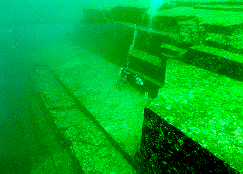
| Originally posted by Alccode If you look at the original article that Magnetonium posted regarding these ruins off of Japan, you'll see that one of the scientists on the "other side" mention that the formations actually seem natural for the type of rock involved. From what I remember, that kind of rock tends to form sharp and straight boundaries like that seen in the photo. It makes it look like they're "stairs" but really they're not. (Kind of like how we tend to see human "faces" on stellar objects like the moon or Mars, but upon closer inspection they're just natural phenomena.) And even if you look at the picture, you'll see that, sure, it looks like steps in general, but actually, there are a lot of inconsistencies and imperfections -- weird angles and the like, that make it seem at least a strange design for a man-made structure, if not outright a natural phenomenon. I'm not totally against this and it would be pretty cool for us to discover an ancient underwater city (and all that implies, though maybe not going so far as aliens), but from the evidence and testimony so far it seems like it's probably more of a natural formation than anything else. At least the ones off the coast of Japan. Haven't seen pictures of the Cuban ones, etc., but it may be a similar case. |
| quote: |
| Originally posted by {b.s.e.} Right, so how does a primitive and unknown civilisation go about building a monument such as this 10,000 years ago? I can assure you, the Jews didn't build that. |

| quote: |
| Originally posted by Alccode |
Powered by: vBulletin
Copyright © 2000-2021, Jelsoft Enterprises Ltd.