|
Strange gigantic symbols carved in Andes long ago:
http://www.hows.org.uk/personal/hil...cand/candel.htm
| quote: |
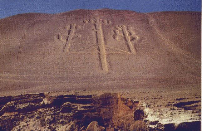
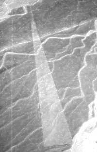
One of the most engimatic giant ground drawings (or "geoglyphs") in South America is seen best from several miles out at sea. Etched into a sloping hill at Pisco Bay on the Peruvian coast, this strange figure looks vaguely like a candlestick; thus, its name "The Candelabra of the Andes." The Candelabra is 595 feet long and can be seen from as far as 12 miles out to sea. Pottery found near the figure has been carbondated at 200 BC and is assignable to the Paracas Culture. Separated by 130 miles from the Nazca Plain, with its famed giant figures, the Candelabra apparently is not the work of the Nazca people. It is puzzling why that such a figure would be placed where it could be seen best by sailors. As with Costa Rica's stone spheres, the Candelabra's makers, purpose, and symbology are in doubt. The Pisco geoglyph really doesn't match the motifs in our books on South American archeology. Some archeologists say it is only a trident, but who ever saw a trident like this? F. Joseph, the author of the present article, thinks it looks like a Jimson weed! Furthermore, he states that there is a miniature version of the Candelabra drawn on a rock in California's Cleveland National Forest. Joseph associates the two candelabras in this way: The ancient inhabitants of Peru voyaged to California to collect Jimson weed and other hallucinatory drugs. When they sailed back to Peru with their cargo, they used the Pisco geoglyph as a navigational aid!
Situated 120 miles north west of nazca is one of the largest of all geoglyphs the 700ft high trident on the mountain side at the bay of Paracas. This mysterious geoglyph is etched into the ground to a depth of around 2 feet, and outlined by stones which may have been placed at a later date. No-one knows for certain the age of the original carving. However, an expedition by the French writer Robert Charroux in 1969, noted that, although the mountainside was exposed to the wind, the wind contained no dust or sand. Chatroux thus concluded that the trident carving could have been drawn millennia ago and yet still have avoided any significant erosion. The trident symbol at Paracas is a major clue to its origin. According to local legend, this carved trident represents the lightning rod of the god Viracocha, who was worshipped throughout South America.
|
Giant of Atacama
http://www.vivatravelguides.com/sou...a-de-los-andes/
| quote: |
Location:
Pisco, Peru
An image carved into the sandstone cliffs along the Pisco Bay is said to be one of the most mysterious archeological sights in South America. It is often called the Candelabra de los Andes, which translates to Candlestick of the Andes, because of its resemblance to a candlestick. It can be seen from sea from as far as 12 miles.
It is often attributed to the Paracas Culture of the first millennium BC, but in reality no one is sure exactly when or why it was made. Because of this, there are many conspiracy theories regarding the carving. One of the stranger and more far fetched theories was begun by a man named Frank Joseph. He suggested that it resembles jimson, which is a plant sometimes used as a hallucinogenic drug. He thought that those who made the carving journeyed to Northern California, the nearest location jimson can be found, and used the carving as a way to help them navigate their way home.
It is doubtful we will ever know the real origin of this carving. However, we can be sure that the mystery surrounding this carving will always be part of what draws so many tourists to the site.
|
http://www.science-frontiers.com/sf102/sf102a02.htm
| quote: |
One of the most engimatic giant ground drawings (or "geoglyphs") in South America is seen best from several miles out at sea. Etched into a sloping hill at Pisco Bay on the Peruvian coast, this strange figure looks vaguely like a candlestick; thus, its name "The Candelabra of the Andes." The Candelabra is 595 feet long and can be seen from as far as 12 miles out to sea. Pottery found near the figure has been carbondated at 200 BC and is assignable to the Paracas Culture. Separated by 130 miles from the Nazca Plain, with its famed giant figures, the Candelabra apparently is not the work of the Nazca people. It is puzzling why that such a figure would be placed where it could be seen best by sailors. As with Costa Rica's stone spheres, the Candelabra's makers, purpose, and symbology are in doubt.
The Pisco geoglyph really doesn't match the motifs in our books on South American archeology. Some archeologists say it is only a trident, but who ever saw a trident like this? F. Joseph, the author of the present article, thinks it looks like a Jimson weed! Furthermore, he states that there is a miniature version of the Candelabra drawn on a rock in California's Cleveland National Forest. Joseph associates the two candelabras in this way: The ancient inhabitants of Peru voyaged to California to collect Jimson weed and other hallucinatory drugs. When they sailed back to Peru with their cargo, they used the Pisco geoglyph as a navigational aid! (Joseph, Frank; "The Candelabra of the Andes," The Ancient American, 2:10, no. 10, 1995.)
|
http://www.newciv.org/nl/newslog.ph...0039-000038.htm
| quote: |
Geoglyphs are classified as rock art, which also includes pictographs and petroglyphs. Pictographs are rock paintings while petroglyphs are rock engravings. Cave paintings, drawings, petroglyphs, geoglyphs, hieroglyphs and more have been used all over the world for centuries.
Created by the ancients and left for us to explore and ponder, these symbols held great meaning for those civilizations who created them. Some, like the Egyptian Hieroglyphs, we know to be the cultures written language. Others, like cave drawings, express the daily lives or held religious significance for their designers. There are many however that offers more questions and possible answers then one mind can conceive. Among these are the great Geoglyphs found in locations around the globe.
In South America, the lines at Nazca are of the most famous geoglyphs, but they are hardly the only ones. South of Nazca, about 850 miles, is perhaps the world's largest human figure, etched into the side of Solitary Mountain. The Giant of Atacama at Cerro Unitas, in Chile, about 600 miles south of Nazca, is an incredible 393 feet high and is surrounded by lines similar to those at Nazca. Just 130 miles from Nazca, dug into a sloping hill at Pisco Bay on the Peruvian coast. This drawing looks very much like a candlestick - which gives it the name of "The Candelabra of the Andes". There has been much speculation about the purpose of the 595-foot high candelabra, but no definitive answer. It is constructed in a different manner to the Nazca lines, using trenches up to one meter in depth, and is best viewed from out at sea. It can be seen from as far away as 12 miles. Pottery found near the figure has been carbon dated to 200 BC. Interestingly enough, the Incan city of Cuzco was created in the shape of a puma. Its inhabitants were known as "members of the body of the puma".
In North America along the Colorado River from Nevada to the Gulf of California are more than 200 huge figures. One such figure is 176 feet in length. Over 600 geoglyphs have been discovered in the southwest United States and nearby areas of Mexico. The first to be discovered was the giant near Blythe, California by a pilot in 1923. Like the Nazca figures, the Blythe effigies are large and give the impression they were designed to be viewed from the air. Also in common with the Nazca figures, clearing away the surface gravel to expose the lighter-colored soil formed the geoglyphs. Although they are thought to date from a much later period (Setzler 1952), none of the Blythe figures match the size of the largest Nazca drawings. Also the human figures and horse like creatures are much cruder in form, typically having solid-area bodies and sticklike appendages, somewhat similar to some of the Chilean effigies. At China Lake, California, a great star burst can be found and the giant of Paradise Valley in Southwestern Montana that is around 1,287 ft. long with an arm span of about 330 ft! We can also move to Ohio and the Great Serpent Mound. Found just north of Quartzite, Arizona, is the Bouse Fisherman:
The English geoglyphs, like the White Horse of Uffington, England, are mostly chalk figures. In Oxfordshire, England, a layer of soil and mossy vegetation was chipped away in the shape of a 360-foot-long horse to reveal the white, underlying chalk. These require constant maintenance to stop them disappearing back beneath grass and soil. This lack of durability means that many others are bound to have disappeared centuries ago. Who knows how many have been lost to us through the years?
Why were these designed? It would seem logical that these ancient civilizations had much more to be concerned with then giant works of art. Were they messages to their Gods? Possible since most appear to be best viewed from the sky or at great distances. Were they a remembrance of ancient times before them when flight was possible? Around the world there are references of great-lost knowledge and a powerful civilization, ancient even to those we now consider ancient. Atlantis perhaps? Is there a connection binding them we have yet to understand?
New thought is finally emerging in the study of sacred, ancient mysteries and the way these stories appear to be repeating themselves. With thousands of amateur and professional archaeologists sharing discoveries online, similarities are being discovered in some Native American rock-art symbolism and that found in other parts of the world. This means ancient people from other cultures could have migrated here thousands of years ago (or vice versa).
Most interesting are those experts who find geoglyphs interpretation that parallels myth and legend found in all of humanity. This suggest that all cultures on earth had origin from a common influence or had contact long before currently believed.
In this section we will take a closer look at some of the remarkable geoglyphs, the regions around them and explore the many possibilities. Open your minds to old thinking, new ideas and what we have yet to even imagine. |
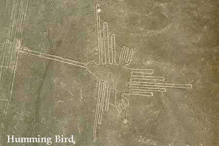
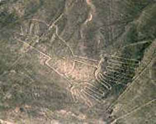
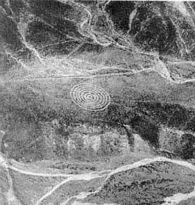
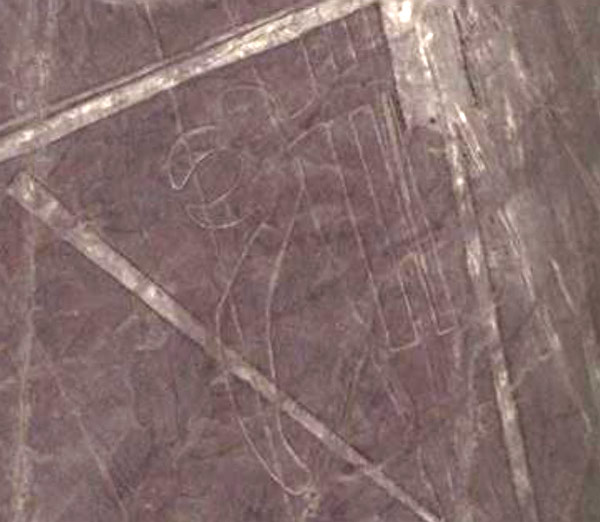
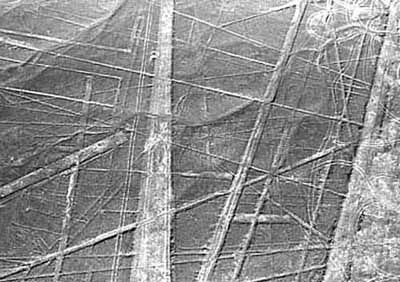
Perhaps the most famous of them all are the Nazca Lines ... did Nazca people really do these things? These are gigantic long lines that can be only well distinguished when viewed from air.


http://cache.eb.com/eb/image?id=20502&rendTypeId=4
| quote: |
The Nazca Lines are located in the Nazca Desert, a high arid plateau that stretches between the towns of Nazca and Palpa on the pampa (a large flat area of southern Peru). The desolate plain of the Peruvian coast which comprises the Pampas of San Jose (Jumana), Socos, El Ingenio and others in the province of Nasca, is 400 Km. South of Lima, covers an area of approximately 450 km2, of sandy desert as well as the slopes of the contours of the Andes. They cover nearly 400 square miles of desert. Etched in the surface of the desert pampa sand about 300 hundred figures made of straight lines, geometric shapes most clearly visible from the air.
Nazca Plain
The Nazca plain is virtually unique for its ability to preserve the markings upon it, due to the combination of the climate (one of the driest on Earth, with only twenty minutes of rainfall per year) and the flat, stony ground which minimises the effect of the wind at ground level. With no dust or sand to cover the plain, and little rain or wind to erode it, lines drawn here tend to stay drawn. These factors, combined with the existence of a lighter-coloured subsoil beneath the desert crust, provide a vast writing pad that is ideally suited to the artist who wants to leave his mark for eternity.
The pebbles which cover the surface of the desert contain ferrous oxide. The exposure of centuries has given them a dark patina. When the gravel is removed, they contrast with the color underneath. In this way the lines were drawn as furrows of a lighter color, even though in some cases they became prints. In other cases, the stones defining the lines and drawings form small lateral humps of different sizes. Some drawings, especially the early ones, were made by removing the stones and gravel from their contours and in this way the figures stood out in high relief.
The concentration and juxtaposition of the lines and drawings leave no doubt that they required intensive long-term labor as is demonstrated by the stylistic continuity of the designs, which clearly correspond to the different stages of cultural changes.
Designs, Myths and Metaphors
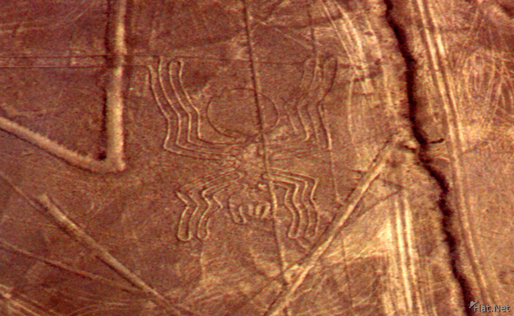
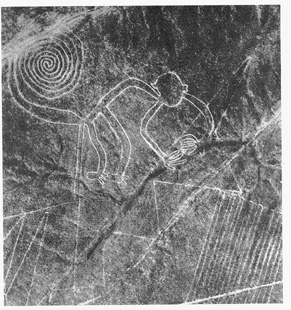
There appear to be various designs consisting of figures of animals, flowers and plants, objects, and anthropomorphic figures of colossal proportions made with well-defined lines. An example of this is the drawing of a weird being with two enormous hands, one normal and the other with only four fingers.
|
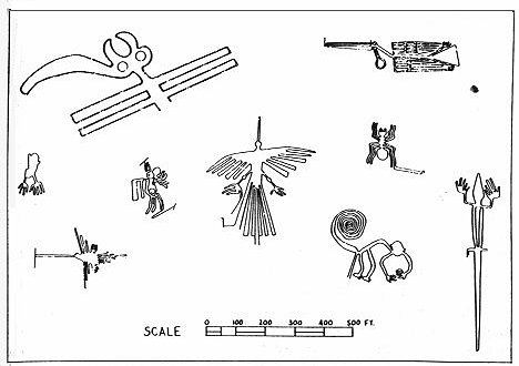
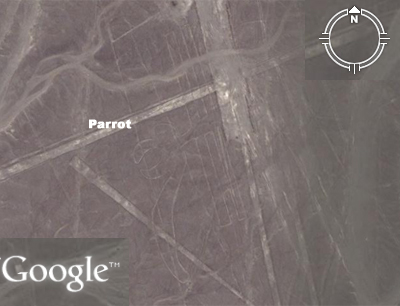
Symbols Map
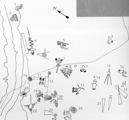
1. Killer Whale
2. Wing
3. Baby Condor
4. Bird
5. Animal
6. Spiral
7. Lizard
8. Tree
9. Hands
10. Spiral
11. Spider
12. Flower
13. Dog
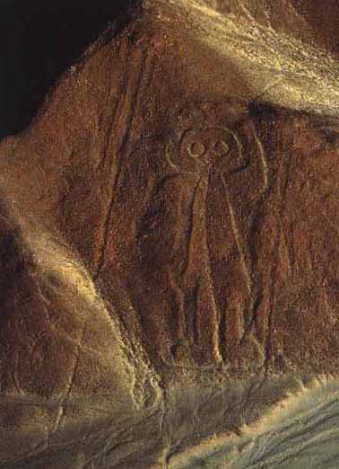
14. Astronaut
15. Triangle
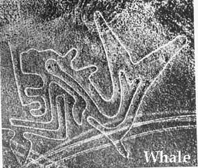
16. Whale
17. Trapazoids
18. Star
19. Pelican
20. Bird
21. Trapazoid
22. Hummingbird
23. Trapezoid
24. Monkey
25. Llama
26. Trapezoids
http://www.therealperu.co.uk/guide/nazcalines.aspx
| quote: |
THE NAZCA LINES - ENIGMA OF THE AGES
Close up to one of the Nazca Lines
Nazca Lines 101 The Nazca Lines provide one of the enduring images of Peru. These colossal geometric and artistic patterns etched in the desert south of Nazca have also engraved themselves on our collective memory.
The Lines were re-discovered in the 1920s and were first thought to have been created by the Incas, but it now seems clear that they are the legacy of a much older culture that developed over 2,300 years ago.
Today, frustratingly little is known about the Nazca culture despite finds of mummies, huge irrigation systems and some highly-decorated ceramics. We can still only wonder at what they were trying to accomplish by making these enormous shapes in the desert, and we can only begin to guess at how they created their greatest legacy, the Nazca Lines themselves.
Across 500 square kilometres of the arid Peruvian pampa are scattered huge trapezoids, animal figures and long straight lines etched in the earth. The amazing thing is that many of these complex designs are so large (some of the lines are over 6 miles in length) that the whole design can only possibly be seen from the air. This has obviously led to some fanciful theories about their purpose. Runways for alien spaceships, the site of gigantic pre-Columbian Olympic Games and even ancient minimalist art have all been proposed.
Some have proposed that the Nazca Lines represented 'the largest astronomy book in the world', believing they were intended to point to astronomical events at the horizon, and this was the theory supported by Maria Reiche, a German archaeologist who studied the Nazca Lines for over 40 years. However, this theory was effectively discarded in 1968, when American astronomer Gerald Hawkins plotted the lines to analyze by computer their relationship with various celestial bodies. Applying the same technique he used to deduce an astronomical key for Stonehenge several years earlier, Hawkins found that the Nazca lines - at least the ones he studied - were random, astronomically speaking. However, this in turn has been called into question as it was based on the lines' relationships to european constellations such as Orion - many of which aren't even visible from the southern hemisphere!
This being a pretty valid criticism, the most likely explanation at the moment seems to be that the lines are markers to sacred sites, a kind of precursor to the Inca 'ceque' system. In this explanation, the lines acted as pointers to the mountain deities of the distant Andes and were created to ensure that the gods knew where to direct the spring melt-waters.
Since the Nazca culture do not seem to have developed written records, we will never know the real explanation for the creation of the Nazca Lines, but in some ways that is perhaps their greatest attraction. Like the Pyramids of Egypt and the statues of Easter Island, the Nazca Lines have a timeless ability to captivate our imaginations, just as they might have captivated their creators, the Nazca people. As Maria Reiche, who dedicated more than 50 years of her life studying the geoglyphs, once said, "we will never know all the answers, that's what a good mystery is all about!"
Just about everybody has their own pet theory and, to be honest, your opinion will probably be just as valid as anyone else's so by far the best thing is to go and visit the Lines yourself so you can make up your own mind - who knows, something may strike you that no-one's thought of before!
Although there is a viewing platform constructed by Maria Reiche by the side of Panamericana (the motorway which crosses the Pampa), the best way by far to view the lines is by air. Our trips can feature options to fly over the Nazca Lines either from the town of Nazca itself or from the nearby city of Ica. We use highly manoeuvrable light aircraft with expert pilots to make sure that you not only get the best possible view of the Nazca Lines, but that you also get those all-important photographs!
|
But then there are some odd lines like these that raise questions ...

___________________
Whenever you go and buy something, you are affecting someone somewhere, be it environment, a person, or a community - you're making a statement with what you buy. So make it a smart choice ... Its a big picture
|


 i've been to AUTEC many times (FYI there is another facility similar to it in Hawaii. been there too)

